Posts

Showing posts with the label fell running

Bob Graham Leg 3 Recce
Image
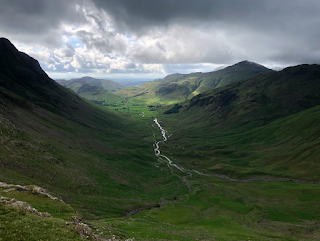
The dreaded leg 3; the leg that I'd read so much about..."the climbing leg". Well, on Sunday it was my turn to see for myself. Leg 3 poses some logistical challenges for a recce; namely because the start (Dunmail Raise) and end (Wasdale) are a good hour and thirty minutes away from each other by car. Because of this, I'd arranged with Abigail (the BGR widow) to collect me from Seathwaite in Borrowdale. To that end, I'd run leg 3 and then walk from Wasdale Head via Sty Head to Seathwaite. After a short and slow walk from Grasmere, I reached the starting point at Dunmail Raise. It was 6.00am and there was a little collective of people parked in the lay-by. I didn't get close enough to say hello, but I have a pretty strong feeling that they were a support crew for a Bob Graham attempt. I crossed the stile and began the steep climb up to Steel Fell and Dead Pike. The weather was pretty good; no rain and relatively mild. Some patches of blue sky were appearin...

Bob Graham Leg 2 recce

Image
It was a sunny and mild April morning as we drove along the A66 towards Threlkeld. My legs were still a little beaten from the Manchester Marathon and from the Loughrigg Fell race the evening before, but nevertheless, I was keen to make the most of the weather and the time in the Lakes to do a recce of leg 2 of the Bob Graham round. When I plotted the route I’d come to consider leg 2 as one of the easier sections of the round; a long slog of a climb up to Clough Head from Threlkeld and then a long, but steady, ridge run over the Dodds, Helvellyn and down to the Grisedale Tarn. In a way this is exactly what leg 2 is, however, what I hadn’t accounted for was the amount of relative elevation loss and gain whilst on the ridge. Leg 2 “officially” begins in Threlkeld, heading south by the disused quarry and then onto Hausewell Brow. For convenience, Abigail dropped me off just south of Threlkeld so that I could begin the route along the Old Coach Road beneath the Threlkeld Knott...

Loughrigg Fell Race 2019

Image
Three days after the Manchester Marathon and I was huddled with two hundred or so other runners at Rothay Park in Ambleside awaiting the start of the Loughrigg Fell race; a four mile out and back evening race. We'd had a stunning day of Lakeland weather and it was a beautiful evening as the last of the day's sun cast long shadows over the surrounding fells. I was unsure of how I would perform so I positioned myself further back than usual. I realised my error as soon as we set off as two hundred people all funnelled onto the narrow stone bridge crossing the River Rothay. Shortly after the bridge, the route zig zags up a gravel track. I felt reasonably good so I managed to meander past some of the other runners to try to get myself a little more space. After about half a mile, the track turns to fell and I was able to begin picking my own way over the terrain. My watch soon buzzed to signify I'd completed the first mile; at this stage the incline increased and the hard w...

Bob Graham Leg 1 recce

So my Bob Graham preparations have begun in earnest. I've earmarked the summer of 2020 for my attempt and I'm doing all I can between now and then to make sure the attempt is a successful one. I've broadly broken the training down into two halves; being 'Bob Graham' fit - that is, being able to run 66 miles and 27,000ft in under twenty-four hours - and being familiar enough with each leg of the route so that navigation is as straightforward as it can possibly be on the attempt itself. The first is a little easier as I have enough hills and challenging terrain around me in Kent to get my fitness to where it needs to be. The second is a little harder as it's not as if I can nip up to the Lakes every weekend to recce each leg. What I can do however is aim to recce each of the five legs each time we visit the Lakes, which is typically four times a year. Mid-February; Abigail and I are up in the Lakes for a few days. I messaged my friend Steve to see if he would b...

Jarrett's Jaunt fell race 2019

Image
On an unseasonably mild Saturday in February I parked up in Wath Brow, just beside the River Ehen. I followed a stream of runners to the race HQ; a horsebox at the side of road. Two friendly chaps gave me my race number and took my £4 entry fee. Jarrett's Jaunt is a handicap race; the handicap having been worked out in the weeks prior and based on performance in recent fell races. For me this was tricky as this was my first fell race and so my handicap was calculated based on my parkrun times. Writing my start time on the back of my hand, I realised I was in the final few batches of runners... no pressure then. After a short warm-up run, I made my way to the race start. The race start was wonderfully unceremonious; due to the handicap, myself and two other runners waiting for the clock to reach 1.11pm and 30 seconds and off we went. The route climbs quickly along Nannycatch Road and then up onto Flat Fell. It's a climb of around 750ft over about a mile. I took it st...

Ben Nevis

Image
Red Burn On something of a whim, Abigail and I had decided to drive to the Highlands for three days in the October break. The weather forecast wasn't brilliant, but I was determined that if we'd driven all that way I would have a crack at running Britain's highest mountain. So, early on a dark and misty October morning, I left our hotel and took the short drive to Fort William. I parked at the Glen Nevis visitors centre. The car park was empty, except for one chap who I overtook just as I crossed the River Nevis. As the day started to break, I started to climb. At first the gradient was relatively tame, however, the path soon became steep and the steps deeper. I had originally planned to run a circular route over the Carn Mor Dearg arete, however, visibility was very poor and so I opted to run a simple out and back along the main tourist path. The CMD would have to wait until another day. The steepening path, and the worsening weather, made the ascent heavy going....

The North Western Fells

Image
Heading up Whiteless Pike Sitting at my desk at some point in early summer I'd plotted a speculative fell running route from Buttermere via Whiteless Pike and Crag Hill, all the way over to Causey Pike and Barrow. If I'm perfectly honest, I saved it and then never looked at it again until we arrived in the Lakes on our next trip. The route was around 12 miles, not huge, but there was a hefty amount of ups and downs. I saw it as a greedy run in that the route deliberately did lots of out and backs and criss-crossing to pack in as my Wainwrights as possible. Regardless, I loaded the route onto my watch, plotted the route on my OS map and set off very early on a Sunday morning in late August. I parked next to the church in Buttermere. The sun had only really just risen and, looking up towards Whiteless Pike and beyond, most of my route appeared to be in the clouds. I ran down into Buttermere village, crossed the bridge opposite the Bridge Hotel and took a sharp right followi...

The Far Eastern Fells

Image
This was something of an undertaking; I’d been planning a long fell run for months and had selected the far eastern fells as a good location as I’d be able to ridge-run whilst hoovering up a collection of new Wainwrights. After a long-ish drive, I parked near The Coombs at Howtown. There was a fine rain in the air and visibility wasn’t great. My route started with a quick dart up Hallin Fell. Standing at 388 metres, I should have had a good view over Ullswater…I didn’t. The only moderately impressive aspect was the large cairn. Anyway, onwards. Re-crossing the road near where I parked, I followed the path to the right of the church before heading up the steep and rough path over Steel Knotts and Pikeawassa. After Pikeawassa I had ended up getting soaked by dense bracken as I followed the wall towards Brownthwaite Crag. At this point I took a left and passed the remains of an old hunting lodge overlooking Ullswater. The cloud was clearing a little, so I was took in some views. ...

Llyn Geirionydd & Llyn Crafnant

I tried my best to make the most of our short time in Snowdonia and this run didn't disappoint. Leaving our hostel at Dolwyddelan early, I headed northeast over the Sarn Helen Roman road route. The farm track quickly turns to trail and it wasn't long before I was steadily climbing. The sun started to rise just as I began my descent from Rhiwddolion. A steep and slippery descent brought me onto the A5, which I followed west for a couple of miles. I was wearing my trail shoes and the tarmac wasn't the nicest surface to be running on. Shortly after Swallow Falls I took a right turn at the Ty-Hyll house, climbing an unrelentingly steep road up to Tynymynydd, where I then turned left and followed the forest road to Llyn Geirionydd. Llyn Geirionydd looked beautiful in morning sun; a light mist hung over the water and the valley was perfectly silent. I followed the eastern bank of the lake before bearing west over the steep forest trail into the adjoining valley. Water was run...

Great Bourne and Starling Dodd

Image
Looking down into Ennerdale whilst descending from Starling Dodd. A bit of unfinished business this one. I'd intended to run Great Borne and Starling Dodd earlier this week as part of my loop around Mellbreak and Hen Comb. As I mentioned, the tail end of Storm Brian was still lingering and it made for quite a challenging run, hence why it was cut short. So, with much improved weather conditions, I re-plotted the route and headed out early to bag another two Wainwrights. Parking at the National Trust car park beneath Bowness Knott at Ennerdale Water, I ran briefly up the road before taking a sharp right and heading up the steep path to the Knott and Rake Beck. The path is relatively comfortable to run, minus a few steep sections where I had to slow down to avoid large patches of mud and/or bog. At 230m I reached Brown How, where the path takes a sharp left and becomes unrelentingly steep and considerably more challenging. I followed the path over the narrow contours, keeping...

Fellbarrow and Low Fell

Image
I've long been fascinated by the outlying and less frequented Wainwrights. I fancied doing a run that didn't require a long drive early in the morning and one that was a little more forgiving given that my legs were still suffering after the previous day's activities. Fellbarrow and Low Fell stand alone next to Loweswater. To me they've always looked a bit geographically isolated and not as attractive as their larger cousins across Lorton Vale. Nonetheless, they're there to be climbed/run. I parked the car at Waterend at the head of Loweswater. There's a decent little car park by the roadside there. Immediately opposite the car park I began my run heading up Grange Lane, a little tarmac road leading to a public bridleway. I headed north on the bridleway. The bridleway is flat and relatively mud-free for the time of year. After approximately a mile, I took a sharp right to the east, following a steep, but clear path up Smithy Fell. The path gets a little lost...

Mellbreak and Hen Comb

Image
Mellbreak - photo by Michael Graham This was a tricky and frustrating bugger of a run. I'd originally planned to run over Mellbreak, up to Starling Dodd, along to Great Borne and then down and over Hen Comb. Annoyingly, the arse end of Storm Brian was still loitering and the visibility was quite poor. The journey started badly as I hit a rock the size of a football and dragged it beneath the car. In the dark and pissing rain, I used the torch on my phone to check for damage underneath the car. All looked OK, but it still put me in a bad mood. I parked in Loweswater next to a farm gate at Church Bridge. Following a cobbled track south, I was soon heading up Raven Crag and White Crag. The wind was a shock to the system, taking my breath a few times. In fact, as the path up Raven Crag became narrower and steeper, and the gusts got stronger, I did wonder about aborting. I carried on and the ascent soon became easier as the path flattened and the northern summit of Mellbreak app...