Kong Mini Mountain Marathon - Dolgellau
On an incredibly wet and windy Sunday morning in Dolgellau, North Wales, I jogged from our hotel to the Dolgellau Institute to register for the third and final instalment of the Kong Mini Mountain Marathon for 2023. Mini Mountain Marathons are, ostensibly, straightforward events; participants are given a map at the start and the map shows twenty-five 'control points' to be reached in whatever sequence the participant sees fit. Control points furthest away, or highest up, are allocated a higher points value. The aim is for the participant to select their own route, and to 'dib in' to as many of the control points as possible within a four hour time limit. It's basically orienteering on steroids.
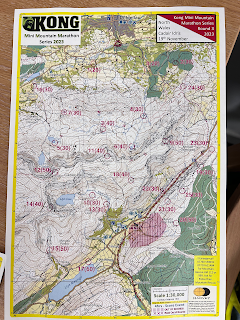
As I walked to the start, I surveyed the map; there were two control points (1 and 8) close to the start. CP1 was to west, and CP8 was to the east. I'd already decided that I would aim to move broadly in a circle to get to as many of the control points as I could. I opted to head east first.
CP8 was an easy find - tethered to a bridge crossing Afon Arran. From here, the obvious next control point would be CP2 which I could see was on a curve on what appeared to be a forestry track. As I ran up the track, I was reasonably confident I could continue on through the forest and then head south towards CP24. After bagging CP2, I soon realised my logic was flawed as the forestry track comes to an abrupt end and, short of clambering through the dense and boggy heather, I'd have to double-back onto the road. This was a frustrating ten minutes wasted.
 |
| Nav errors between CP2 and CP24 |
Back onto the road, I begin climbing in a broadly south-easterly direction toward CP24. The weather by now is awful and I can't tell whether the route I'm following is a path or a stream as the water pours over my shoes. I reach a grassy col and spend a few minutes looking for the checkpoint. I eventually find the orange and white orienteering flag getting battered by the wind.
By now I've bagged 80 points, so I feel a bit more relaxed that I've got some points on the board. I now have a choice; I can continue south/south east towards CP23 with the intention of then picking up the ridge upon to Cadiar Idris itself, or I can stay low and head west towards CP4. With the weather being as it is, I opted to stay low and began picking my way through the boggy terrain towards CP4. I can see that CP4 sits somewhere at the intersection between Afon Arran and a wall. I look down towards where I think the checkpoint should be but I can't see anything but rain and mist. I decide on a change of plan; there's another checkpoint, CP6, at the head of Afon Arran near a small tarn - all I need to do is follow the river up to the tarn, where I could the double back and bag CP4 with the benefit of having the wind behind me. This seems like a better idea.
The climb up to Llyn Arran tarn is steady but boggy and it seems to go on forever. I eventually see the tarn appear from a small cauldron in the crags and, to my relief, I see CP6. I look at my map and take stock; my original plan to retrace my steps back down Afon Arran to CP4 doesn't seem as appealing now I've seen how boggy it is. I realise that to the east, but much higher up on the ridge, is CP9 worth 50 points. I look up to the ridge; in the brief moments where the mist and rain clear, I can see that there's a handful of rock/scree gullies at what appear to be climbable pitches. I convince myself that aiming for CP9 is a better option and remind myself that I can always turn back if I can't find an easy way up.
A short way from Llyn Arran, I reach one of the gullies and begin climbing it. The rocks are slippery, but I manage to gain quite a bit of height quite quickly. After around ten minutes of climbing the gradient eases and I find myself on boggy ground once again. Ahead of me I can see a fence. Fortunately, this fence is marked on the map and so I realise that I can simply follow it north east towards CP9. To my relief, CP9 appears from the gloom and I bag another 50 points.
 |
| Between CP6 and CP9: up the gully onto the ridge |
From here I know that my choices are somewhat limited. I don't fancy going down the way I came up, nor do I fancy picking my way down to CP23 as I'd already bagged most of the checkpoints in the east. Given that I was now two hours in, my only real choice was to head west along the ridge towards CP11 on Mynydd Moel and, eventually, onto CP12 on Cadair Idris itself. This is exactly what I do.
The three/four miles to the Cadair Idris summit are steady despite the awful weather. I can't see anything and, by now, I'm soaking wet. CP11 is quickly and easily bagged and, after some trouble finding it, I reach CP12 just to the east of the summit shelter. I look at my watch; I have just over an hour to get down and back to the finish.
Having already surveyed my OS map the evening before, I know that the only option to get down is via the Foxes Path - a steep northerly descent between Llyn y Gadair and Llyn Gafr. As I descend, I pass numerous other competitors who are heading up. It makes me wonder whether I've made a poor route choice as everyone seems to be going in the opposite direction to me. By now it doesn't matter as my only focus is getting back to the finish.
The ground to the west of Llyn Gafr is extremely wet and the path becomes indistinguishable. Given that I'm running out of time, I opt not to bag CP5 somewhere to my right and instead keep heading north. It's here that I encounter my first major obstacle; the river (which ordinarily would have been easy to stride across, or at the very least, step through) was in spate and I could see that the force of the water coming down from the tarn was incredibly strong. At first I stepped in, waist deep, to see if I could stride through - I couldn't; the force of the water was too strong and I risked being knocked over. Instead, I headed upstream to find a more suitable crossing spot. This also proved to be fruitless; it seemed like there were no suitable spots to cross. I carried on upstream and found a section with several large rocks scattered across the width of the river. The rocks looked very slippery and were just out of my jumping range so I aborted. I looked at the map again; by now I'd wasted ten minutes trying to cross this river and, in the process, I had climbed a long way from the path. I opted to head back down to where the path naturally crossed the river to see whether I could make it across here. I worked out that if I were to cross here I'd need to keep some large rocks to my left in order to lean against to combat the force of the water coming from my right. The crossing at this point was around 4m across and I knew it was probably my only option. Lifting my backpack high onto my shoulders, I waded in. Knees were submerged, hips were submerged, and soon my chest was submerged. I leant my left hand against the large rocks. The force of the water was immense. With one final step I clambered up onto the bank.
 |
| Wasted time trying to cross the river |
Relief was met with the realisation that I was now likely to breach the 4 hour time limit and therefore receive a time penalty. This didn't matter to me now - my main focus was on getting somewhere warm and dry. The route descends rapidly towards the Gwernan Lake Hotel where CP16 sat waiting for me. I quickly dibbed in and then headed north east along a farm road towards the finish. 12.15pm ticked by and so I knew I'd definitely face a time penalty. The tarmac of the farm road was a relief after the hours of bog. An abrupt northernly turn took me down through the muddy and steep forested section that I recognised from four hours previous. A few hairpin bends later, I was at the finish dibbing-in in 4 hours 19 minutes. I'd scored 260 points in total, with a 90 point reduction for being late...ouch.
I really enjoyed this event despite the weather. The time penalty is annoying, but I know exactly where I wasted the time, so it feels like my route choice was still reasonably good.
A big thank you to all of the organisers and the volunteers!


