Gatliff 50k Cross Country
Herbert Gatliff was one of the founding members of the Croydon YHA Group, founded in 1934. In 1984, to celebrate its fiftieth anniversary, the Gatliff 50k ultra marathon was organised. Now in its 35th year, the Gatliff 50k is still going strong. The course changes every year, but it broadly follows the same principle as it's always done; rural cross country around West Kent/East Sussex, multiple checkpoints and a time limit of ten hours. Participants can walk, jog or run...all for just a £10 entry fee.
The route isn't marked, and written turn-by-turn instructions are provided on the day. Saying that, a sketch map is made available in advance and so I used this to familiarise myself with the route.
Leg 1: Edenbridge to Toys Hill
At around 8.25am I left Edenbridge Rugby Club and followed the directions out of the town, through the churchyard and into open fields. As I passed a number of other participants, I soon realised that I needed to reassess my finish time expectations; heavy rainfall had made the conditions underfoot hard going.
The route up Toys Hill is steep. In fact, you climb in the region of 600ft in about 1.5 miles. There was little chance of any views from the top as the rain was now falling again. I ended up running in circles when I reached the top as I managed to confuse myself as to where the checkpoint would be. Fortunately, a few fellow runners were nearby and I cheekily followed them into the National Trust car park where a large camper van awaited. I got my checkpoint card stamped, swigged some blackcurrant squash and then checked the route details for the second leg.
Leg 2: Toys Hill to Sevenoaks Weald
In my preparations for the event, I'd plotted a very rough sketch of the map onto my watch so that I would have a vague idea of the direction of travel if I got lost or lost the route instructions. From the Toys Hill car park, I could see that I needed to head east towards the village of Ide Hill and then through the woodland where I'd take a hard right.
Leaving Toys Hill I deviated from the course ever so slightly and made some good lines through the woodland. I hadn't deviated anywhere near as much as I thought I had as I'd soon picked up the route again, passing a number of hikers who'd left far earlier than I had.
Leaving the village of Ide Hill, I headed through the woodland and began to descend. The paths were sodden and I needed to be careful where I was placing my feet. It was in one of those moments where I was concentrating too much on my feet and not enough on the route that I missed my turning. Having descended around 0.5 of a mile, I really didn't fancy turning around, heading back up hill and retracing my steps, so I instead worked out that so long as I kept going in a straight line I'd eventually pick up the route again. Eventually, after around a mile or two I saw some fellow runners coming from the opposite direction; my approach from the other direction confused them somewhat! Either way, I was then able to recheck the route details and get back on course.
The remainder of leg 2 was relatively straightforward, except for another minor route miscalculation where I ended up having to cross a hefty barbed wire fence to get back on course. I was relieved when I reached Sevenoaks Weald, crossed the village green and got my checkpoint card stamped in the village hall.
Leg 3: Sevenoaks Weald to Chiddingstone
This leg started badly as I again took the wrong turn out of the village hall. I hated the idea of retracing my steps so instead cut through a hefty hedge full of brambles. I heard a tearing sound and looked down to see that a bunch of brambles had ripped across my thigh and my shin. Blood started to pour out. I had no tissues or wet wipes, so I carried on.
This leg had some of the most significant patches of mud on the route. Whenever I got onto firmer ground I tried to bang the mud off my shoes, but I was fairly caked by this stage,
As I approached Chiddingstone I first had to pass through two fields, one had a large excitable horse in it, the other was full of cattle. The horse didn't seem too bothered by me, but the cattle seemed far more interested; I didn't know whether to walk through them or run faster. One of the younger ones started trundling behind me...fortunately I was near the edge of the field so I was able to make a hasty escape over a gate.
Chiddingstone is a very pretty village and the sight of CP3 at the village hall was very welcome. This was the 'lunch checkpoint'. It was a little early for lunch, but by this stage I was 18 miles in, tired and needed to get my energy levels up. I forced half a cheese and tomato sandwich down me, downed two cups of (undiluted) squash and had a few bites of a Clif energy bar. My legs were stinging from the brambles earlier on.
Just as I was about to leave I spotted someone I knew from parkrun. I tell a lie, he spotted me first. Chris Carter called out "Dan!" and we chatted about how we were both doing. Chris and I's paths seem to cross quite a bit; we often see each other at Pegwell Bay parkrun, but we also bumped into each other 300 miles away at the Whinlatter Forest parkrun in the summer. Anyway, we wished each other good luck and I was on my way.
Leg 4: Chiddingstone to Cowden
Hard, hard, hard. This leg didn't start well as I was hit by some unfortunate stomach cramps as soon as I left Chiddingstone. To make matters worse, the route instructions at this became a little complicated and a number of other participants found themselves standing still, scratching their heads.
I'd studied this section of the route beforehand and had a decent idea of where to go, so I managed to pull away from some of the other runners and make some reasonable progress.
The route turns abruptly to the west and you follow Kent Water towards the village of Cowden. This was the hardest section of the event for me as by now as I was devoid of any energy. I had to alternate between running and walking. The underfoot conditions made things ten times worse.
I only have fuzzy memories of this section. I remember entering Cowden and forgetting to check the route details, instead I asked a nice old lady where the village hall was. It's a good job I asked her...I was heading in completely the wrong direction.
The village hall was a welcome relief. I allowed myself a bit of time to take on some food and water. I also texted Abigail and my dad as up until now they had no idea how I was getting on. My message to my dad said simply "Checkpoint 4 of 5. Brutal".
One of the friendly volunteers seemed concerned about the amount of blood on my legs from the brambles!
Leg 5: Cowden to Dry Hill
After leaving Cowden I just tried to get my head down. The weather was beginning to turn again and I was tired of being on my feet for so long. The route undulates and so I ended up fast walking the uphill sections and then running downhill.
I tried the tactic of "run 0.9 of a mile and then walk 0.1". This helped, but it was still heavy going. I noticed that there were far fewer runners around me know. I think I only saw three or four on this section; the usual faces that I'd been overtaking/being overtaken by since CP2.
I chatted to one chap and he seemed just as tired as me. It was reassuring that I was seemingly in the same boat as everyone else.
After a long progressive drag upwards, the fifth and final checkpoint at Dry Hill came into view. A lovely gentleman informed me that it was only another four miles and it was all downhill from now on. I had a mince pie and left as quickly as I could.
Leg 6: Dry Hill to Edenbridge
The final leg. The chap at CP5 was right, it was largely downhill, but by this point I was well over 50k and downhill felt pretty much the same as uphill. Still, I chugged on. The course eventually finds its way to the banks of the River Eden, which then winds its way back to Edenbridge.
I knew at this stage that I was on the home leg and that it was a case of just putting one foot in front of the other. I chatted to a fellow runner and we took it in turns to take the lead and push the pace. This chap turned out to be 'Little' Dave Cumins. Every single stile seemed to be getting taller and harder to get over.
As I approached Edenbridge, the footpaths diverged and I took the path of least resistance, forging a route across a couple of fields before eventually rejoining the correct route. In the distance I could see the rugby posts...what a welcome sight!
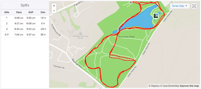
As the rain started to fall once again, I came clattering across the rugby pitches and to the door of the rugby club. I stopped my watch... a moving time of 5 hrs 34 mins. I worked out I'd been on the course for somewhere in the region of 6 hrs 15 to 6 hrs 25. To my surprise I'd run 34 miles.... that's 55km!
I wasted minutes trying to get my shoes off so that I could actually get inside to hand my checkpoint card in! Eventually, I was given a warm welcome by the ladies on the desk, given my completion certificate and told to help myself to some food. 6 hrs 20 in total.
All in all this is a great event. For a £10 entry fee it is remarkably well organised and well supported. The route instructions are excellent, and the route itself is very carefully chosen. I'll definitely be there next year!
The route isn't marked, and written turn-by-turn instructions are provided on the day. Saying that, a sketch map is made available in advance and so I used this to familiarise myself with the route.
 |
| Leg 1 |
At around 8.25am I left Edenbridge Rugby Club and followed the directions out of the town, through the churchyard and into open fields. As I passed a number of other participants, I soon realised that I needed to reassess my finish time expectations; heavy rainfall had made the conditions underfoot hard going.
The route up Toys Hill is steep. In fact, you climb in the region of 600ft in about 1.5 miles. There was little chance of any views from the top as the rain was now falling again. I ended up running in circles when I reached the top as I managed to confuse myself as to where the checkpoint would be. Fortunately, a few fellow runners were nearby and I cheekily followed them into the National Trust car park where a large camper van awaited. I got my checkpoint card stamped, swigged some blackcurrant squash and then checked the route details for the second leg.
Leg 2: Toys Hill to Sevenoaks Weald
In my preparations for the event, I'd plotted a very rough sketch of the map onto my watch so that I would have a vague idea of the direction of travel if I got lost or lost the route instructions. From the Toys Hill car park, I could see that I needed to head east towards the village of Ide Hill and then through the woodland where I'd take a hard right.
Leaving Toys Hill I deviated from the course ever so slightly and made some good lines through the woodland. I hadn't deviated anywhere near as much as I thought I had as I'd soon picked up the route again, passing a number of hikers who'd left far earlier than I had.
 |
| Leg 2 |
The remainder of leg 2 was relatively straightforward, except for another minor route miscalculation where I ended up having to cross a hefty barbed wire fence to get back on course. I was relieved when I reached Sevenoaks Weald, crossed the village green and got my checkpoint card stamped in the village hall.
 |
| Leg 3 |
This leg started badly as I again took the wrong turn out of the village hall. I hated the idea of retracing my steps so instead cut through a hefty hedge full of brambles. I heard a tearing sound and looked down to see that a bunch of brambles had ripped across my thigh and my shin. Blood started to pour out. I had no tissues or wet wipes, so I carried on.
This leg had some of the most significant patches of mud on the route. Whenever I got onto firmer ground I tried to bang the mud off my shoes, but I was fairly caked by this stage,
As I approached Chiddingstone I first had to pass through two fields, one had a large excitable horse in it, the other was full of cattle. The horse didn't seem too bothered by me, but the cattle seemed far more interested; I didn't know whether to walk through them or run faster. One of the younger ones started trundling behind me...fortunately I was near the edge of the field so I was able to make a hasty escape over a gate.
Chiddingstone is a very pretty village and the sight of CP3 at the village hall was very welcome. This was the 'lunch checkpoint'. It was a little early for lunch, but by this stage I was 18 miles in, tired and needed to get my energy levels up. I forced half a cheese and tomato sandwich down me, downed two cups of (undiluted) squash and had a few bites of a Clif energy bar. My legs were stinging from the brambles earlier on.
Just as I was about to leave I spotted someone I knew from parkrun. I tell a lie, he spotted me first. Chris Carter called out "Dan!" and we chatted about how we were both doing. Chris and I's paths seem to cross quite a bit; we often see each other at Pegwell Bay parkrun, but we also bumped into each other 300 miles away at the Whinlatter Forest parkrun in the summer. Anyway, we wished each other good luck and I was on my way.
Leg 4: Chiddingstone to Cowden
Hard, hard, hard. This leg didn't start well as I was hit by some unfortunate stomach cramps as soon as I left Chiddingstone. To make matters worse, the route instructions at this became a little complicated and a number of other participants found themselves standing still, scratching their heads.
 |
| Leg 4 |
I'd studied this section of the route beforehand and had a decent idea of where to go, so I managed to pull away from some of the other runners and make some reasonable progress.
The route turns abruptly to the west and you follow Kent Water towards the village of Cowden. This was the hardest section of the event for me as by now as I was devoid of any energy. I had to alternate between running and walking. The underfoot conditions made things ten times worse.
I only have fuzzy memories of this section. I remember entering Cowden and forgetting to check the route details, instead I asked a nice old lady where the village hall was. It's a good job I asked her...I was heading in completely the wrong direction.
The village hall was a welcome relief. I allowed myself a bit of time to take on some food and water. I also texted Abigail and my dad as up until now they had no idea how I was getting on. My message to my dad said simply "Checkpoint 4 of 5. Brutal".
One of the friendly volunteers seemed concerned about the amount of blood on my legs from the brambles!
 |
| Leg 5 |
After leaving Cowden I just tried to get my head down. The weather was beginning to turn again and I was tired of being on my feet for so long. The route undulates and so I ended up fast walking the uphill sections and then running downhill.
I tried the tactic of "run 0.9 of a mile and then walk 0.1". This helped, but it was still heavy going. I noticed that there were far fewer runners around me know. I think I only saw three or four on this section; the usual faces that I'd been overtaking/being overtaken by since CP2.
I chatted to one chap and he seemed just as tired as me. It was reassuring that I was seemingly in the same boat as everyone else.
After a long progressive drag upwards, the fifth and final checkpoint at Dry Hill came into view. A lovely gentleman informed me that it was only another four miles and it was all downhill from now on. I had a mince pie and left as quickly as I could.
 |
| Leg 6 |
The final leg. The chap at CP5 was right, it was largely downhill, but by this point I was well over 50k and downhill felt pretty much the same as uphill. Still, I chugged on. The course eventually finds its way to the banks of the River Eden, which then winds its way back to Edenbridge.
I knew at this stage that I was on the home leg and that it was a case of just putting one foot in front of the other. I chatted to a fellow runner and we took it in turns to take the lead and push the pace. This chap turned out to be 'Little' Dave Cumins. Every single stile seemed to be getting taller and harder to get over.
As I approached Edenbridge, the footpaths diverged and I took the path of least resistance, forging a route across a couple of fields before eventually rejoining the correct route. In the distance I could see the rugby posts...what a welcome sight!
As the rain started to fall once again, I came clattering across the rugby pitches and to the door of the rugby club. I stopped my watch... a moving time of 5 hrs 34 mins. I worked out I'd been on the course for somewhere in the region of 6 hrs 15 to 6 hrs 25. To my surprise I'd run 34 miles.... that's 55km!
I wasted minutes trying to get my shoes off so that I could actually get inside to hand my checkpoint card in! Eventually, I was given a warm welcome by the ladies on the desk, given my completion certificate and told to help myself to some food. 6 hrs 20 in total.
All in all this is a great event. For a £10 entry fee it is remarkably well organised and well supported. The route instructions are excellent, and the route itself is very carefully chosen. I'll definitely be there next year!
Relive 'Gatliff 50k Cross Country'